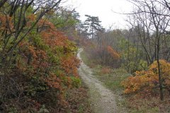
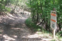
The border of Keszthelyi-mountains and Balaton at Balatongyörök is a magnificent creation of nature.
The mountains are ideal for hiking, there are noumerous possibilities for families and also for people who are up to a bigger challenge.
Choices are endless: a cave, viewpoints, sights, unique plants and animals can be found in the cool woods. You can take a map from the local Tourinform bureau and start your adventure. These maps are so detailed, the only hardship is the choice between the many possibilities.
Pele apó path is a route made directly for children at Balatongyörök by the Balaton Uplands National Park. It consists of 38 stops and is 8.5 kilometers long. It is accessible from multiple places, from Szépkilátó, Africa Museum or Bélap-valley. Information boards provide knowledge in Hungarian and English.
Some popular routes:
Szépkilátó: It is a relaxed stroll to the border of the village, where the most beautiful scenery of the lake can be found. Underneath lies the Roman spring, and there are dozens of diners offering a wide variety of consumables.
Fireplace: Walking along the main street of the village, passing main road 71, proceeding to the forest you are going to bump into the place, which is perfect for picnics and outdoor cooking, also has shelters against rain
The area is 2-2.5 kms away from the village. From here, multiple viewpoints are easy to access by foot. Bisekütető is 600 meters into the forest and then a right turn, Bél Mátyás viewpoint is on Garga mountain, to the right on a dirt road, Batsányi viewpoint is after a small field on a hill to the right..
Szobakü cave is cca. 5 kms from the centre of the village, starting on the driveway starting from the bacon oven, and after 1200 meters, turning right at the second mileage, onto the dirt road. After about 1700 meters you will see an opening leading up to the opposite mountain. To the right of the valley, after 150 meters, we find the mossy rocks that hide the cave.
You can reach St. Michael’s Hill by following the road to the left after the ABC in the center of the village, to St. Michael’s Hill. The distance is about 2500 meters. The church on St Michael’s Hill can be seen from afar.
The “Csodabogyós” (Miracle) Cave can be reached on foot from the Africa Museum of Balatonederics, the GPS coordinates of the base building of the cave are 46.7923, 17.37026.
Regular boating and nordic walking tours in the area are offered to both professionals and beginners. The national blue-hiking route runs in the Keszthely Mountains. More information about the routes can be found at www.turistautak.hu.
Walk to Becehegy
There are many beautiful 19th-century listed press houses and cellars in Becehegy. During the walk you can admire the magnificent panorama between the cozy cellars, and if you thirst, you can go to one of the cellars to taste good wine from Györök.
“Büdöskút” Arboretum
Starting from the bacon oven in Balatongyörök, you can reach the tree-collection arboretum created in 1937 by walking about 5 km. In the area there is a wooden chalet, which is suitable for baking. It was named after the spring water once in the area. The source has dried up as a result of bauxite mining. Once a wild boar farm, later a foal breeding farm. Near the site, which was declared a protected area in 1976, is the cemetery for heroic police dogs. The GPS coordinates for this area are 46.76149 / 17.348947.
The Büdöskút Arboretum is the most visited area in the southern part of the Keszthely Mountains, 12 km from Keszthely, on the border of Balatongyörök. It consists of a variety of forest parts of various types and is functionally well suited to the needs of nature, tranquility and silence lovers.


